
Last week we spent 3 luxurious days in Las Vegas, courtesy
of a timeshare outfit that simply wouldn’t take no for an answer. They had a
place to stow the 5th wheel so we accepted the offer, sat through an
hour or so of sales pitch and enjoyed the luxurious room for a few days. Even
watched Notre Dame edge past MSU.
 |
| View from our hotel - pretty close to the airport. |
Liz once again found a nice spot from which we could hit a
couple of national parks. We’re now ensconced in Lutherwood RV park, two miles and
15 turns of dirt road off Utah 89, 40 miles south of Bryce Canyon and about the
same northeast of Zion. Despite the lack of wi-fi (my, aren’t I getting picky) or
phone reception Lutherwood is more than you can expect for less than 20 bucks a
night. That includes living among herds of deer, flocks of turkey and a new
year's celebration by a Christians-using-Jewish-holidays sect.

 |
| Dozen wild turkey in Lutheran Camp Lutherwood |
Monday thru Wednesday were spent at Bryce Canyon. Like
Crater Lake, it’s misnamed. It’s actually the eroded edge of a plateau. Of
course the erosion is something special, due to the soft sandstone of the plateau.
It got its name from a local settler whose property backed up on one of the
more spectacular box canyons below the plateau. His historic comment was “It’s
a hell of a place to lose a cow.”


The park had a definite Grand Canyon flavor, down to the
wonderful shuttle service with half a dozen stops on a 5 or so mile route at
the major scenic spots and trailheads down into the hoodoos. Ah yes, hoodoos.
These are the features that make Bryce Canyon unique. They’re easier to show
than explain, so these pictures should explain them better than any words.


The hiking trails take you down into the hoodoos, making for
my least favorite hiking style – first down, then up. We did about 4 miles a
day. At 8,000 feet that was all I wanted, though Liz considered it just
moderate exercise. What I get for marrying down half a generation. Actually,
the trails are quite smooth and hard packed and wide enough for people to pass
easily. Once again, thank the CCC. Really, our tax dollars were never better
spent.


Along with the regular shuttle was a twice a day tour 17
miles to Rainbow Point. The name is from all the colors visible in the various
geological features below you. From this point you can see up to 75 miles in
nearly a full circle. Barely visible is Navajo mountain, a personal favorite of
mine. It’s the little volcano that couldn’t. Some several million years ago a
magma bubble pushed the ground up 12,000 feet or more into the air, then quit.
Thaaaat close to being a real volcano.
 |
| That faint blue bulge just over the hoodoo, that's Navajo Mountain, 75 miles away. |
Liz Here
20 years ago my cousin Bertie from Simbach in Germany and his friend Peter Hoffman flew to the US to tour national parks. They told me that Bryce was the Best! It took me 20 years but I made a point to finally go to Bryce to decide for myself. Bryce is truly great.
Mike:
Thursday and Friday were for Zion. We’d been there before
and it will remain a favorite. Spectacular scenery and first class treatment
from the park service. Like Bryce, there’s a shuttle service all along its 10
mile length, though unlike Bryce and like the Grand Canyon south rim, it’s
compulsory. Really nice, one comes along
every 10 minutes. Hiking trails up the canyon walls are laid out from one
stop to another. There are several, graded from easy to difficult. I’ll take
moderate for four miles or so, Alec. Sprinkle in about 3 million other visitors
a year, apparently half and half U.S. and foreign. You’ll never be alone on the
trails.


 |
| Now squint. Do you see the penguin? |
 |
| Hiking trail. Yes, we were down there. |

 |
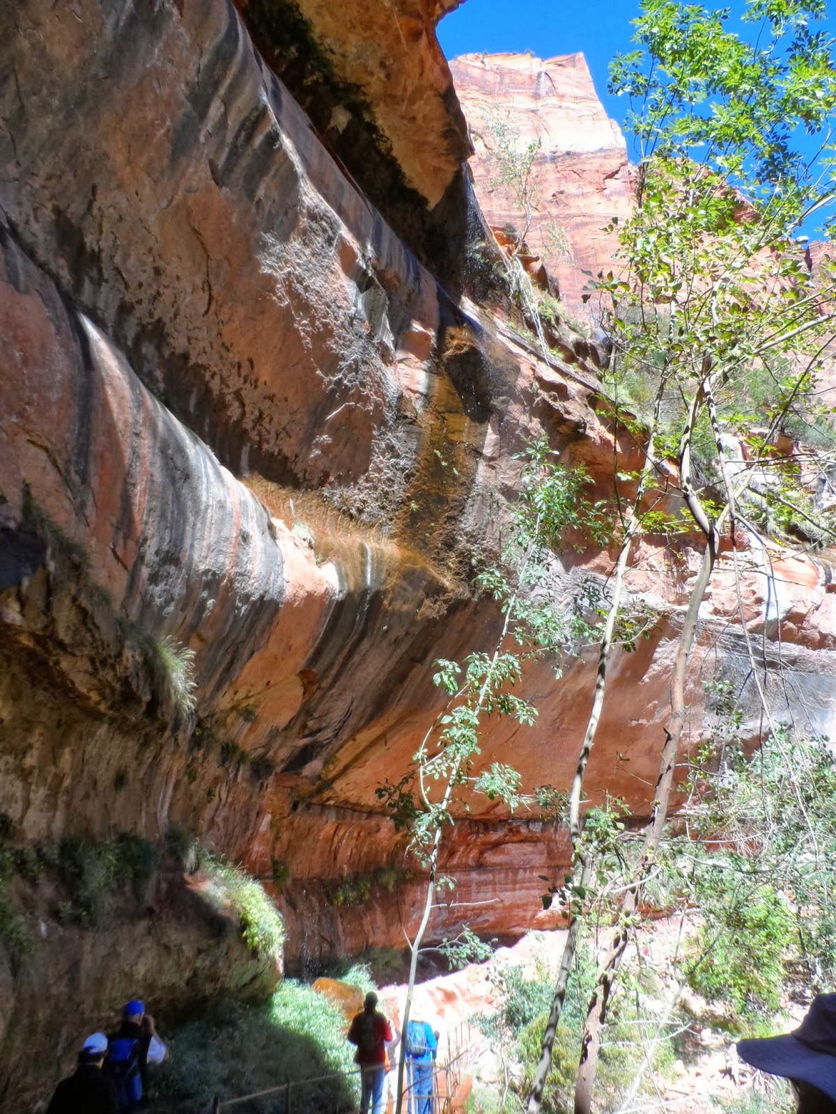
| I've been seeing these arches all through the southwest. A geologist finally explained them to me. Water percolates down till it hits an impermeable layer, then starts pushing. Hard. |


 |
| Look, the prickly pears are almost ripe! |
Friday night was below freezing. It looks as though we’d
better be moving along. On our way to Arizona we’ll be investigating the huge
federal lands in southern Utah along scenic highway 12. I’ve been having a ball
with the dashcam, though the resolution is not wonderful and the files are
huge. Fair warning, I’ll be glad to inflict hours of scenery on anyone who
expresses even a casual interest.
It's now Tuesday and we've finally hit a camp with Wi-Fi. Capitol Reef was closed down due to some Washington silliness. They won't stop us from seeing Monument Valley tomorrow, though. It's all on a reservation and run by some primitive, simple Indian tribe. Nothing like good old American can-do!