Sunday, October 21, 2012

A cruise ship in the desert

We're finally in our temporary new home, Gold Canyon RV & Golf Resort just south of Apache Junction, darn near under the Superstition Mountains. We're surrounded by permanently placed park model trailers, most with sun porch and carport. Makes our rig look embarrassingly temporary. Well, we are. Actually, there are many motor homes and 5th wheels spread out throughout the resort and the permanent residents seem delighted to welcome new faces.

At the Friday Morning Buzz, a regularly scheduled coffee clatch, the hostess (!) assured us that the staff was committed to make this park a cruise ship in the desert. It is a darn nice place, though it really doesn't get going 'til the first of November. Now I'm going to pull a dirty trick: instead of downloading a bunch of pictures, I'm just going to send you here........ http://www.robertsresorts.com/
.......... They do it so much better. If the website looks awfully glossy and professional, well so does the resort, at a very reasonable price, at least for our situation. Did I mention that they seem to want to make sure there is always an available activity going on, from pool (billiards, usually a bizarre variation of 8-ball on 8 beautifully maintained 9 foot tables), pool (swimming, mornings devoted to water aerobics), golf (A ring-shaped par 3 around the clubhouse. What it lacks in yardage, it more than makes up for in devilishness), pickle ball (apparently a cross between ping-pong and tennis) and fairly frequent pot-lucks and holiday parties.

We received a call from the lady who sold us our 5th wheel, Sheila Bima. Months later, and the lady wants to know how the trailer is treating us! Sheila, General RV of Wixom has done very well by us. From a very reasonable price for a beautiful used Cougar in excellent condition to a very informative and necessary 5-hour class in trailer essentials. 12,000 miles later we still appreciate that information.

October 21, 2012 on Site 441 in Gold Canyon RV and Golf Resort near Apache Junction and Pheonix, Az.


I've clean forgotten to fill in on the leadup to Gold Canyon. On the way south from the Grand Canyon we spent a few days near Sedona at Dead Horse Ranch State Park. One grows up with the impression that it never rains in the desert. Not precisely true. Liz surprised me with a four wheel ATV guided trip in the National Forest (well, that's what they call it) . So of course it rained. Our cute-as-a-button guide, Audrey, kept referring to the summer monsoons. It's just so hard for a Michigan boy to take seriously the concept of a monsoon in an area that  has 10-12 inches of rainfall a year.

ATV in Sedona


Double Rainbows over the Desert
 
Can you see how cold Liz feels? Many tourist couples under-estimate cold in higher elevated Sedona.  

We also paid a visit to the little copper mining town of Jerome. There's a huge pit mine and then a little town built into the mountain, pretty much right to the top. Jerome's heyday was from the late 1880's to a peak in the 1920's and a total collapse when the mine closed in 1953.  Now, it depends almost entirely on tourists, though several artists and photographers also make it their home. Every now and then you've just got to visit a tourist trap.

Jail in Jerome


For some reason, I didn't get many good pictures of Jerome. Not to worry, the internet once again to the rescue.   http://www.jeromechamber.com/index.htm

Liz here.
We met my friend, Erin O'Connell, a relocated realtor from Hell, Mi. for Thai food after our ATV tour. Erin was a fashion model and as such she was the Frigidaire Lady and the Delco Lady. She has a master in English from Wayne State. Her daughter Jody Fodor authored "SAT Word Slam" for all of you prepping for the SAT to get into college. Check it out here............. http://www.youtube.com/watch?v=IMDuYcGY__s


Thursday, October 11, 2012

Meteor Crater and the Grand Canyon

Ever since I was little, I'd wanted to visit Meteor Crater. I finally got there. Not that I wasn't thrilled to be there, nor awestruck at imagining the incredible force that made this nearly a mile across and 600 foot deep hole in the desert in a matter of seconds somewhere around fifty thousand years ago, nor that thanks to desert conditions it is nearly perfectly preserved. It's just that once you'd paid your 16 bucks each and entered the hallowed ground, that was about it. We were allowed to walk about 200 yards around the crater rim in the company of a guide and take all the pictures we wished while he told us of the history and geology of the crater, most of which I'd memorized 40 or 50 years ago. If you're in the neighborhood, don't hesitate to stop in. On the other hand, realize it's actually only going to take up a couple of hours.

Meteor Crater. There it is, nearly a mile across and 600 feet deep.

Maybe a better perspective. It is near Winslow, Az.
Liz here: Mike at Meteor Crater with his new "What's your Ology" T-shirt. First new tee since we met.
Portion of Meteor that created Meteor Crater.  
Liz here:
Mike thinks that most people know about Meteor Crater the way that he knows it. Learning about a hole in the ground created by a meteorite was news to me. 50,000 years ago a meteor ended its 500 million mile year long race through space to collide with Earth. Our young and enthusiastic tour guide, Darren is Navajo and proud to be about to finish a geology degree. He told us a joke about a visitor, a lady who stated that it was lucky that the meteor did not hit I-40. Darren thought that she was joking so he told her that the meteor hit Route 66 instead so they built I-40. So she asked him in all seriousness, "How many cars did it take out?"


Back to Mike:
By the way, that day was a full one. Up at dawn, finish up Petrified Forest, see Meteor Crater, stop at Flagstaff Walmart (only to discover this was one of the "no boondocking here" places) meet a fascinating California couple  who told us just where to camp for free at the canyon, make the 70 mile drive to the canyon (half hour wait at a roadblock while a helicopter ambulance rescued a downed motorcyclist) over a scenic and twisty two-lane road then find the elusive free camping site just outside the Grand Canyon National Park. Location? My lips are sealed, we may need to use it again. Liz rates it as our best free campsite ever. Secluded, comfortable, shady and the US Forestry Service provides near-constant security.  Absolutely no utilities (water, electric). On the other hand, no rules on when you can run your generator.


Rescue operation.

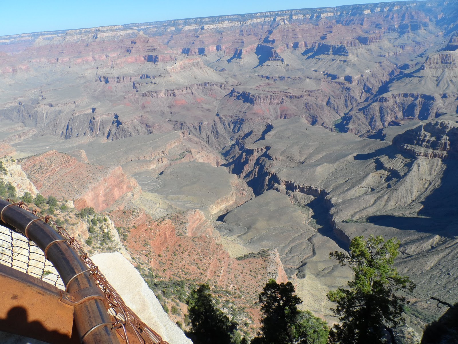
 The big day! We've both seen the canyon before but we felt in a rush to see it from this new perspective. Still a fifteen mile trip from park boundaries to the visitor center. Then a few hundred yard walk to the rim. It's difficult to take it all in even once you've seen it. Is that really ten (or more) miles across to the other side? Where's the river? I was promised a river. Oh, the canyon's so deep (over a mile) and the river so far down and the lower canyon so narrow you can only see it from certain viewpoints? Yes, the Grand Canyon is in fact two separate entities. The big, broad valley that completely overwhelms your sense of scale and the deep narrow cut through hard crustal rocks you can barely see. Even when you get a chance to see the river it looks so tiny and calm. In fact in many places it's a football field across and moving at 20 or 30 mph. It's also so far down, it's in a whole different temperature range than the rims. If it's 80 degrees on the rim, it's probably over 90 at the river. Okay, I'll shut up and show some pictures.


Just a few of the hundreds of dramatic canyon views I took.
A photographer can hardly go wrong. Just wave a camera in the general direction of the other side and press the button.
Actually capturing the scale and majesty is something else....................

Our first intention was to step right out and hike to the bottom of the canyon. Then we saw the trails and realized that getting anywhere useful meant a full day's trek to the bottom, camp, then a nice long vertical walk the next day. Let's rethink this. On the other hand, there are 17 miles of trail along the rim, a shuttle service that'll take you to anywhere along the rim you'd like, lots of museums and historic sites, that magnificent view anywhere you look. Much more do-able! you can walk as long as you like, grab a bus back to the parking lot.

For the 9 days we were there, this was more than enough to keep us occupied. Eating lunch with our feet hanging over a long drop watching the ravens. They act here like nothing we had seen before. There is something about the wind currents of the canyon that causes them to become aerial acrobats, folding their wings and doing barrel rolls, flying at a sheer face at top speed and riding the wind straight up, flying in tandem, one upside right, the other upside down. Hell of a show!

Right along the path, we'd find ripe pinyon nuts. Just crack them with your teeth for the delicious bits inside. Look, a prickly pear bearing fruit. This takes a careful grab with a piece of paper and a pocket knife. Then scrape off the fine sharp needles (first time, I wasn't so careful and paid the price) and peel. The flavor can best be described as subtle. Stop at a lookout, enjoy the view and listen to all the different languages. Like Yellowstone, people come here from around the world. Many of them have seen more of the U.S. than we have.

The squiggly line across the cliffs is part, just part, of the Bright Angel Trail. It disappears to the left and goes all the way to the river, across a bridge and up the other side. 27 miles.

These young folks were having lunch on a precarious ledge next to a vertical drop.
4 young men with 1 female temptress trying to drive the men crazy.

Tourists from ALL over the world.
Prickly pear, with fruit.


On the east end of the park is yet another Pueblo type ruin. Rather than describe it myself, I'll let a better authority do it. Enjoy..............  http://www.nps.gov/grca/photosmultimedia/200703_gatlin_rm_tusayan-wmv.htm

Liz is adamant we get to all the ranger talks we can. They're worth the trouble and a pretty good free show. For example, an hour and a half talk on Grand Canyon architecture. The government and many private parties have been building here since the early 1900's in every style from New England traditional to Mission to '60's functional, looking much like army barracks I've been in at Fort Belvoir, Virginia.  The architect who made the most of the opportunity was Mary Coulter in the early 1900's. As an aside, we also learned of the Kolb brothers, the park's resident photographers for 70 years or so. I'm serious, see these wild men for yourself.  http://www.grandcanyon.org/kolb/kolbphotographs.asp

http://www.youtube.com/watch?v=HLoL8v6Tv1M

A Mary Coulter creation, The Lookout Studio.

Desert View, another Mary Colter design.

The train station, one of only three log stations in the US.
A train runs to and from Williams daily, just down the hill form the El Tovar Hotel.
In the lobby of the El Tovar. Strongly reminiscent of the Lodge at Yellowstone.

We are now in Dead Horse State Park, checking out Jerome, an old mining town up in the hills now a full bore tourist trap. Tomorrow we take a four wheel ATV out in the hills above Sedona. Then dinner with an old friend of Liz's. We've found where we will winter over, a place east of Phoenix called Gold Canyon, in view of Superstition Mountain. Not too expensive, a 9 hole executive golf course on site and many facilities including a gym with steam room, also 8 pool tables along with more activities than any sane person could want. Winter has been following us down the country beginning with late August in Yellowstone (!) and nearly catching us at the Grand Canyon. Time to run for the desert!

Sunday, September 30, 2012

My Life is in Ruins


Seen in parking lot of museum. Staff archeologist perhaps?


Liz here:

We left Moab, Utah and beautiful Arches National Park on Friday, Sept. 21, and drove 130 miles to the Mesa Verde RV Park just outside the national park. This RV park deserves its high rating. It is as nice an RV park as we’ve ever stayed in, run also by Liz and Mike. Shady trees line the RV sites and a gas stove heats a cozy outdoor conversation pit where many a group has sat to discuss the amazing artifacts in Mesa Verde. I swam in the pool and then soaked in a hot tub with a family from North Carolina. They told me about  that evening’s dirt track races. Good idea! So Mike and I had a Mexican dinner in Cortez and went to the races at the nearby Montezuma Fairgrounds after dinner. I’ll let Mike elaborate on the car races.

Mike here:

There's nothing quite like a semi-pro dirt track race on a 1/4 mile bullring. Absolutely nothing up to NASCAR standard here. The stands were hard wood, the refreshments limited to hot dogs grilled while you wait and watery colas, the sound system full of crackles and drop-outs, even the track was sub-par, inadequately watered and breaking up by the feature. Consequently you couldn't see the cars by the tenth lap of any of the races. Because the lighting was so poor, the pictures I took show just a dusty blur of cars going by. I have no idea of what the drivers were using for vision!
 
See what I mean?
 
Liz again:

We set the weekend aside to relax. Mike watched football, golf and NASCAR. On Saturday I washed the dust off the truck and spent Sunday playing on the internet.  I read Superfreakonomics, talked on the phone, cooked and sent out a few postcards. (Sean, we thank you so much for the memory stick with books that Fred passed onto us from you.)


Sunday morning we drove the 18 miles into the Mesa Verde. The drive alone is a drama. In the Visitor’s Center we were introduced to learned a young Finnish archeologist, Gustave Nordschiold who scientifically excavated and documented Mesa Verde in 1870s. When he boxed up artifacts to take to Finland the locals were horrified. The sheriff put him in jail but no law was in place to prevent the taking of artifacts. The Antiquities Act wasn’t passed until 1906 when Teddy Roosevelt established the park. After release from jail he returned to his home in Finland where the artifacts are in a museum there to this day. He married, had a child and died of TB at the age of 26.

See that squiggle? Look up above it, there's even more.  It's part of the road.
 

In Mesa Verde we visit Cliff Palace and Balcony House on ranger guided tours that cost $3.
 
On Monday a very erudite US Park Service ranger toured 30 of us through the Cliff Palace. The rangers’ first task is to describe the complex tour ahead so thoroughly as to dissuade anyone unfit to turn back. The task of climbing and pushing one’s body through openings on long ladders is not for the frail or for those afraid of heights. We hiked a mere ¼ mile in total but we climbed 5 8 to 10 foot ladders including a 100-foot vertical climb to the exit. Our tour included a group of Germans with an English translator. In true German fashion they were most curious and concerned about animal life in Mesa Verde. We saw lizards, deer and ravens. The communal room is called a kiva. It is the name of round spaces below.
 
 
Cliff Palace from across the canyon. Lots of round spaces make this a palace.
 
Closer. Also our very knowledgeable ranger, the only way to see this site and Balcony House, mostly because access to the ruins is so strenuous.


See what I mean?
I have no idea how Indians did this!


Kiva, a ceremonial room. Pueblo Indians still use this basic form.
 
 
Mike  again:

Mesa Verde is all about a vanished people. From 600 - 1275 AD this was a flourishing community. Then everyone just up and left, leaving all kinds of possessions and artifacts in their cliff dwellings. Their descendants, Keresan, Hopi, Tanoan, etc. know all about the exodus but have no idea why. Archeologists can trace their developing culture, agriculture and technology almost year by year and then come to a dead stop with their disappearance.

Typically, we started with the last first. Cliff Palace and Balcony House along with Spruce House are the last of the civilization chain. Apparently the reason for moving into the cliff alcoves had to do with water, always a problem here. Winter snow and rain would seep through the porous sandstone until stopped by a less permeable layer of shale. Coincidentally, these shale layers also contributed to erosion of the sandstone. Thus, many large alcoves automatically had a water source. Hard to get to but spectacular. Okay, I'll shut up and show some more amazing pictures.


Spruce House. Note the multi-stories going right up to the top of the alcove.
These are original 13th century floor joists. The steel turnbuckle above them are holding the structure together.
Though the stonework is superb the mortar has deteriorated. I wonder how our brickwork will look after 600 years?

These beam-ends were hewn 600 years ago with stone axes.


Liz descending into a restored kiva.
Tourist standing along wall of Balcony House.
This is the only concession we saw to the sheer drops adjoining the cliff dwellings.

Mostly, its a sheer drop like this.
Of course, earlier constructions, up on the mesa were in nowhere near as good a shape. Also, it looks as though the cliff dwellers raided them for building materials.

Remains of a 7th or so century pit house. The roof was bent poles and mud with a smoke hole in the center. They were apparently firetraps. Later houses used vertical stone walls, quite similar to Pueblo houses of today.
All that's left of a mid-period village. Remains of villages like this are all over the mesa.
After a few days of climbing up and down cliffs we figured we were up to the challenge of seeing the petgroglyphs. I have no idea why these ancient people decided to decorate the hardest to get to areas but there you are. A 2.8 mile walk with a thousand feet of elevation change, the first mile and a half pretty much along the canyon face. Very cool but pretty damn strenuous.


Right through there, if you please.


We couldn't really complain about this section. There WERE steps!
Somewhere on the left hand side of the picture is more of the trail.


On the other hand, the rock writing is definitely worth the walk.


Pueblo art showing skunks with a bear on the run.

Our last day at Mesa Verde we decided to take a road trip along the Trail of the Ancients to Hovenweep National Monument. More cool ruins, though very different architecture. This site holds 5 different small villages built late in the old people's stay in the area. After that, we got just a bit lost and somehow ended up at Four Corners, the only place four states meet.

Typical Hovenweep ruins. The house at the lower left seems to have been built in a hollow boulder.
Standing in the ruins of one village with another just across the canyon.

Many of the houses seem to have a round room.

Standing in 4 states at once!  Utah, Colorado, New Mexico and Arizona
A digression. While looking through Walmart (No, I don't necessarily approve of Walmart but I do take advantage of their hospitality for free overnight parking and they do have RV supplies and automotive stuff) I saw a bewildering variety of diesel fuel supplements, most containing cetane. While googling it, I came upon the Duramax Forum. They had a good discussion of fuel additives and a list of some that were not approved by GM along with a consensus of which were best. I had no idea that low sulfur fuel (required since 2007) did not lubricate fuel pumps and valve guides as well as the old stuff. Also that diesel fuels were quite variable in their cetane content (cetane is roughly equivalent to octane in gasoline). Anyway, I couldn't find  the additive they most highly recommended, Opti-lube XPD, but Walmart did carry the second best, Diesel Klean. My unloaded fuel mileage immediately went from an abysmal 16 mpg to a much more acceptable 19 mpg. Loaded with trailer, I went from 10-12 mpg to 12-14 mpg. Only took 13 thousand or so miles to find it!

We took off early from Mesa Verde aiming roughly for Meteor Crater but there were a couple of attractions on the way worthy of attention. We headed south and west out of Colorado (I have to keep pinching myself, I'm actually in the Great American Southwest!) through Gallup and stopped at the  Petrified Forest National Park that just happens to be in the Painted Desert, a spectacular stretch of badlands that stretches for Las Vegas to the Four Corners. 225 or so million years ago when reptiles ruled the earth and dinosaurs were just becoming the killer app, the area was wet and tropical with an Amazon-like river running through. Dead trees would be swept down the river and deposited on the outside of bends and buried in sand. Of course, petrified wood is found all over the world but nowhere else in this profusion nor with this kind of chemical infusion. Quartz infused with iron, manganese, uranium and other heavy elements and produced a rainbow of colors. Kind of like the hills surrounding them. Not to mention all kinds of Triassic fossils in these hills. Oh hell, on with the pictures.


Shiprock, namesake for Shiprock, New Mexico.
The Painted Desert. What else could you call it?

I mean, really?
By the way, much of what you see here is bentonite with different chemical traces.
Bentonite is commercially available as Dri-Rite and many brands of kitty litter.


Just because I can't help myself.
Look closer, there are several petrified logs and that lower slope, all small bits of petrified wood.


There is not a natural rock in this picture, it's all petrified wood!

And a lot of it is really colorful.
One area in particular had some huge specimens.

Not a dinosaur but a much older reptile herbivore.
All the fossils in the visitor's center were found nearby, many remarkably complete.
The Park Service maintains a staff archeologist, paleontoligist and biologist. All very busy people.
We ate up the entire day and still hadn't seen all we wanted. No problem. On the south side of the park is a rock shop that welcomed casual campers. Met a really nice couple from Alabama and spent the evening chewing the fat. This is not an isolated ocurrence. Makes travelling that much nicer.


In the rock shop. One of these slabs will set you back a few grand. They mine their own off park property and slice and grind it themselves.
Of course, that meant we felt obligated to patronize the shop in the morning. Picked up a few small pieces of petrified wood (just little stuff, not what the picture shows), postcards, etc. and finished up the park. God Bless that free pass for seniors.

Today we're parked in Homolovi State Park in Az. Some more ruins, tiny compared to what we've been seeing but this time with lots of pot shards, flint scraps. Ran into yet another retiree and spent the afternoon in conversation. While watching the Ryder Cup (Hey, sometimes you luck into a little luxury) Liz looked out the door. A roadrunner was investigating our camp. He ended up getting curious and jumping on our doorstep before wandering off. Later Bob, the retired California State Patrolman I mentioned earlier showed off a dead 2 1/2  foot rattlesnake he'd found just down the road. Life can get very interesting!

Scraps like this littered the ground all over the site.

A smooth river cobble. A flint working tool?

The most complete foundation on the site. One of a hundred or so rooms arranged around two central plazas.
 Again, abandoned around 1300.

Curious Roadrunner paid us a call.

Up close and personal on our steps.

Rattlesnake. Bob got the rattles


Camping in the desert.
Next, Meteor Crater.